Observation
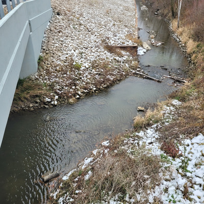
Richmond Drain at 5th Concession
Cedar Creek
Channelized stream

- Data collector
- Ed Zaborski
- Record testers
- Ed Zaborski
- Land use
- Agriculture, Forest
- Bank vegetation
- Trees and shrubs, Grass, Other
- Location description
- This sampling location is immediately south of the bridge, opposite the SW corner of the Marianne Girling Nature Reserve (Nature Conservancy Canada), in the uppermost part of the watershed of the western branch of Cedar Creek. The Richmond Agricultural Drain was constructed in 1885, and enlarged in 1914, to drain a large marsh (Walker's Marsh) for agricultural use. The soils in the area are deep, poorly drained lacustrine clays (Toledo Clay and Jeddo Clay). The area is dominated by extensive field crop agriculture (corn, soybeans, winter wheat), with scattered woodlots (typically deciduous swamp forest) and rural residences. Inputs to the Richmond Drain are dominated by surface runoff (particularly snowmelt and intense rainfall events) and field tiles; ground water usually keeps at least a few centimeters of water in the Drain during the summer. One reason this sampling location is interesting is that it is a spawning site for White Sucker.